Devpost
Participate in our public hackathons
Devpost for Teams
Access your company's private hackathons
Grow your developer ecosystem and promote your platform
Drive innovation, collaboration, and retention within your organization
By use case
Blog
Insights into hackathon planning and participation
Customer stories
Inspiration from peers and other industry leaders
Planning guides
Best practices for planning online and in-person hackathons
Webinars & events
Upcoming events and on-demand recordings
Help desk
Common questions and support documentation
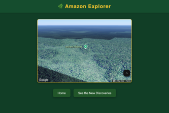
Forest Sentinel: Giving our forests a voice.
SafeStride is a web app that guides users along the safest routes using real-time crime data and smart mapping
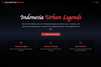
HauntedTrailsIndonesia is your go-to map for ghost stories and urban legends. Ready to explore the unknown? Let’s get haunted.
LotWorks is a map-centered web application that adds a visual dimension to the land development process. It helps you streamline your workflow and gives you unparalleled insights into your business.
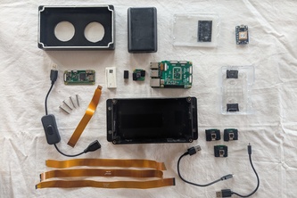
A smart little device that sits on the back of a bike to photograph and map bike paths and other places cars cannot go.
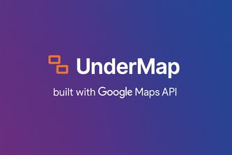
A real-time digital platform to visualize, manage, and analyze underground utilities using geospatial intelligence—enhancing safety, reducing excavation risks, and streamlining utility operations.
PicSeal encrypts images and guards privacy—GPS coordinates hide as the secret key inside each file, unlocking only at the right spot. Shh, no one else knows.
Explore properties virtually with our 3D visualization product suite powered by Google Maps and Unreal Engine, and immerse yourself in a real-world experience of your future home and its location.
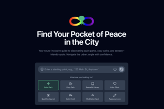
An AI-powered tool to help neurodivergent individuals find calm routes and places by detecting and avoiding overstimulating urban zones.
Mangal Yatra with multi route with multi hop train in India not matter location is like A to B to C to D and so on
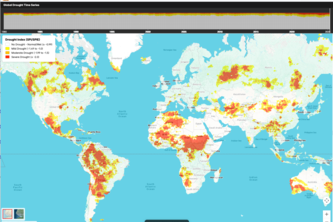
Global Drought Map combines ERA5 drought data, in-browser analytics with DuckDB, and Google Maps JS API and H3 Hexagons for real-time, global drought insights—scalable and accessible for all.
Professional travel guidance with comprehensive legal and cultural insights.
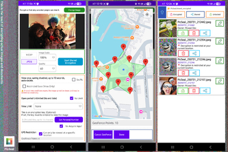
FMFF simplifies field operations with live tracking, smart routing, and powerful insights—giving managers full control and teams real-time clarity, all seamlessly powered by Google Maps.
VolunGo is a gamified, map-powered platform connecting volunteers to live NGO tasks in real time, earn points, track impact, and create change across your city with every action.
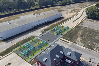
Browser-based 3D street design tool democratizing urban planning - used by advocates, planners, and educational institutions to create community-led infrastructure improvements.
Where Ancient Legends Meet Satellite Vision
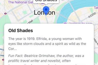
Discover the world through captivating stories! Powered by AI, Wanderpedia generates immersive, location-based narratives in various styles, letting you explore, and share tales about any place.
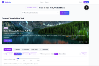
GuideMe: AI-powered self-guided tours. Personalized journeys with interactive maps, AI chat, & voice. Explore uniquely.
WattWise helps users calculate and understand electricity bills instantly—simple, smart, and hassle-free.
MemoryAtlas lets families and citizens pin memories and create cultural journeys on a map - preserving legacy, places, and stories with photos, audio, and timelines for future generations.
Transform your favorite places into captivating stories with AI. Discover the magic hidden in every location through immersive audio narratives.
Find My Store: Turn Search into Store Visits — A Smart, Branded Locator for Every Business.
AI-powered travel recommendations based on your entertainment preferences
Revolutionizing retail with intelligent automation that does predictive analytics and real-time data for seamless inventory management, personalized customer experiences, and optimal store location
145 – 168 of 414