Devpost
Participate in our public hackathons
Devpost for Teams
Access your company's private hackathons
Grow your developer ecosystem and promote your platform
Drive innovation, collaboration, and retention within your organization
By use case
Blog
Insights into hackathon planning and participation
Customer stories
Inspiration from peers and other industry leaders
Planning guides
Best practices for planning online and in-person hackathons
Webinars & events
Upcoming events and on-demand recordings
Help desk
Common questions and support documentation
Flareway is a smart evacuation and emergency guidance platform designed to save lives when every second counts Panic and confusion are often deadlier than the flames. Flareway eliminates uncertainty.
"Experience real roads, not just maps. VR INFO-MAX blends 360° real videos with live maps for smarter, safer, and more reliable travel. Know your route before you go."
A citizen science mobile app to support biodiversity conservation.
A travel app for planning and recording trips. The app combines artificial intelligence (AI) with advanced Google APIs and runs on browsers, iOS and android devices.
A radically immersive, scroll-navigate, AI-powered global explorer that turns your browser into a teleportation portal — blending search, stories, and stunning visuals. Built for dreamers.
Weather Dashboard is a clean, fast web app showing real-time weather and 5-day forecasts worldwide. Built with JS & local storage, it remembers searches for a smooth, clutter-free experience.
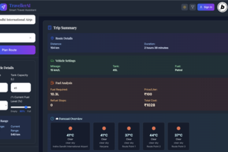
TravellerAI – Your intelligent road trip companion that finds the best fuel stops, cafes, and hotels along your route with real-time insights and smart AI chat support.
@google_map
Explore with GPS navigation, check street view, and get driving directions. • You can easily find your current location • Multiple color schemes are available • Multiple languages supported
Navigate through Stories that Shaped the World
A 3-in-1 App that monitors in real time, via Google Maps, the distance traveled (km), the amount of CO2 (Kg) emitted by each vehicle, and automatically calculates the ecological carbon offset.
Built after a real incident, MAPSAFE guides you safely through dangerous zones using smart paths, voice alerts, and vibration — no screen needed.
A 3D treasure hunt that leads directly to your business
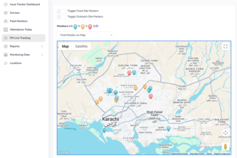
A tracker to track the issues faced by monitors in field while vaccinating
Join the 'Urban Legend Hunters' and start the location-based investistigation for urban legends in your own cities!
A smart mapping platform that connects travelers with hidden local gems, empowering sustainable tourism through real-time community insights and AI-powered recommendations.
We provide a powerful, yet easy-to-use, platform that aggregates and visualizes property information, make data-driven decisions in this rapidly growing region.
Breathe Better: Our app detects real-time air quality and provides personalized health assessments, helping you stay safe and healthy wherever you go!
"Pagiis – Real people. Real places. Right now."
AI-powered food rescue platform that matches donations to those in need using maps, smart routing, and predictive intelligence.
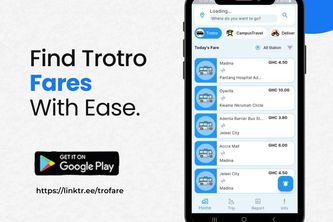
Unlike some countries with BRT system, the real national service of every African is our daily commute using trotro(shared minivan) with no realtime fare information and ride information.
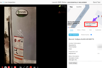
The VuSpex Live Virtual Inspection allows a remote Inspector to perform a virtual inspection and track, in real-time, the GPS coordinates of a remote Field Agent, ensuring integrity of the inspection.
AI-powered trip planner creates custom itineraries based on your destinations, duration, interests, budget & travel style. Get personalized daily plans for your perfect adventure!
Multilingual platform using Google Maps Platform to map monuments, traditions, and landscapes worldwide from real travels — over 240 videos and 580 geolocated entries.
385 – 408 of 414