Devpost
Participate in our public hackathons
Devpost for Teams
Access your company's private hackathons
Grow your developer ecosystem and promote your platform
Drive innovation, collaboration, and retention within your organization
By use case
Blog
Insights into hackathon planning and participation
Customer stories
Inspiration from peers and other industry leaders
Planning guides
Best practices for planning online and in-person hackathons
Webinars & events
Upcoming events and on-demand recordings
Help desk
Common questions and support documentation
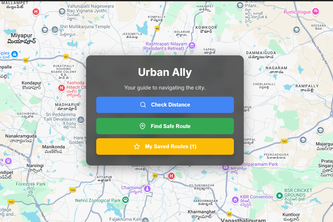
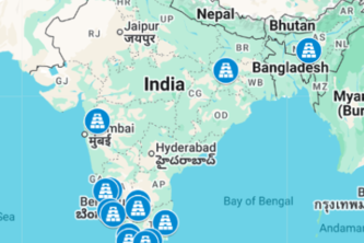
PathGuard is a smart map app that finds the safest walking routes by avoiding high-risk zones and showing nearby safe spots, using Google Maps APIs like Directions, Places, and Heatmaps.
A cultural journey through fifteen sacred groves across India where forests are worshipped as living deities. This map blends heritage, mystery and ecology in a story of spiritual geography.
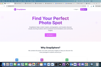
Discover hidden photo spots with vibe-based maps, create personalized moodboards, explore community-shared locations, and enjoy AI vibe classification — making every shoot uniquely yours.
Travel Beyond Boundaries, Create Beyond Imagination😍😍😍 Every Journey Leaves a Mark - Make Yours Unforgettable😎
Find parking spots while avoiding ZTLs
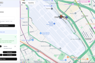
The intelligent way to coordinate rides using AI-powered pickup optimization.
Find truly accessible places. Go beyond generic accessibility symbols. Get detailed photos, videos, and community reviews tailored to your specific accessibility needs.
Powering a sustainable future with smart tech, real savings, and sustainable choices , Solenery makes clean energy simple, seamless, and accessible for every home and project.
With the rise of XR technologies, we are going live inside a digital world phsycially - which will open doors to environmental datas all around us.
Not sure where to go? Meet Mood2Go, your guide to the perfect spot based on your mood, vibe, and how far you want to travel.
ForestWatch combines AI and forest data and displays it on a world map, allowing users to visualize deforestation across years and recognize the importance of sustainability for our future.
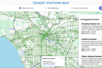
An interactive map focused on California that displays information that would be relevant to building new public transit stations for people in low-income and high-traffic areas.
Pin It. Name It. Deliver It.Making Deliveries Hassle-Free
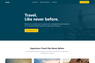
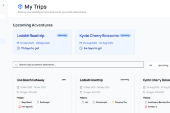
Travie.ai creates personalized trips in seconds by using Google Gemini and Google Maps. Plan, customize, and book trips with real-time details - all in one smart, AI-powered platform.
An interactive visual memory map that turns your location history into a clustered, filtered, and exportable geospatial timeline — powered by Google Maps and AI-driven insights.
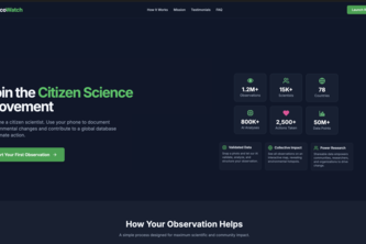
EcoWatch is a citizen science movement turning everyday observations into global climate intelligence, using AI and maps to power real-time environmental action.
Feelscape - Your emotions leave a trail
Its the app for foodie people who likes to eat what they like very much. Foodie people travel long distance for good meal and they need info on how to find that perfect meal with route.
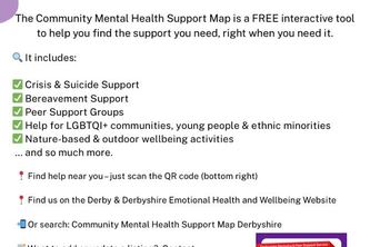
Community Mental Health Support Map – is a simple, interactive support tool that helps people across Derbyshire find mental health and wellbeing support.
Plan smarter, travel better! TouristBuddy uses AI + real-time APIs to suggest routes, weather, budgets, and personalized experiences—all in one seamless assistant.
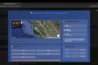
See 40 years of climate change in seconds. Our tool uses Google Earth Engine and AI to visualize the past and predict the future, turning abstract global data into your personal reality.
Route Planner helps users find the fastest, most efficient routes using Google Maps API, with smart optimization for time, distance, and convenience.
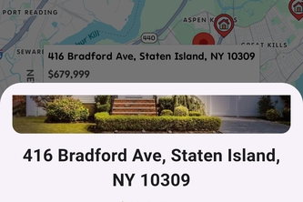
Detailed property listing with greenhouse gas monitoring for buyers concerned about the world's health.
Bonfire lets anyone host real-life events—no followers needed. Spark hangouts, meetups, or chai nights instantly. Real people. Real plans. No gatekeeping. Just connection.
73 – 96 of 414